Our mission
While working at a major landscape architecture firm three years ago, we tried to integrate into the BIM work environment. As we encountered many obstacles, we began to research the best way to make BIM a reality for ourselves and our cohort.
More about us
How to think the BIM way
Over the years, Revit® has become the most popular BIM software. And, since the BIM design process requires all disciplines to use compatible software, Revit® is the natural choice for site designers as well.
To learn more
The key for landscape in Revit®
The Environment for Revit® was created to enable landscape architects & other site planning professionals to transition to BIM while providing the smoothest workflow possible.
See all benefits
Based on automation
Today at Arch-intelligence, we keep developing ways to improve and optimize the BIM-based design and construction process, so professionals of many disciplines can find our tools helpful.
About the tool
×
Our mission:
While working at a major landscape architecture firm few years ago, we started trying to integrate into the BIM work environment. We encountered many obstacles, so we began to research the best way to make BIM a reality for landscape architecture. Over the years, Revit® has become the most advanced and most popular BIM software and since the BIM design process requires all disciplines to use compatible software, Revit® is the natural choice for our field as well.
Our mission is to make the Revit® workflow for landscape architects as convenient and efficient as possible. To achieve this, we created the ENVIRONMENT for Revit® plugin, a powerful set of tools that turns Revit® into the best software on the market for landscape architecture and site design. We understand that creating these tools alone is just the beginning, so we also provide quality free online learning resources to make BIM implementation for all landscape professionals not only achievable but fun.
Today at Arch-intelligence, we keep developing ways to improve and optimize the BIM-based design and construction process, so professionals of many disciplines can find our tools helpful.
Close
×
How to think the BIM way
Implementing BIM technology is different from learning how to use new software; it is more like learning a whole new language or philosophy. We are here to share some of the benefits of this transition and some guidelines for effective landscape BIM projects.
Working with Revit® enables landscape architects to take part in the BIM planning process, and at the same time, allows their employees to spend less time on drawings, renderings, and analysis; thus, giving the users significant leverage. Through working with Revit®, designers can create smart models that will take more and more variables into account, bringing important innovations to life around the biggest issues of our generation, such as climate change, sustainability, diversity, and more.
When a work tool is this complex, one should know it fluently to use it strategically and make it as efficient and cost-saving as possible. To achieve a proper BIM model, you must always think ahead and plan how every element is represented and what information you might need to extract from your model. All this while still avoiding an over-detailed model. Take the extra time to make sure your Revit® families and model types include the correct data; make sure to insert this data and create a schedule template for every category in your model. In doing this, you ensure decrease in production time over the learning period.
Maybe it will take you some time to learn, or perhaps you will get it quickly; whatever happens, don’t be tempted to go back to your comfort zone, and don’t use CAD in BIM, meaning don’t start drawing 2D lines in your model as a quick solution. There is a certain point when implementing BIM where going back to CAD will look like washing your clothes in the river. Be patient with your learning curve and believe that you will reap what you sow once you put in the work.
Close
×
The key for landscape in Revit®
To meet landscape architecture needs, we seek a tool both accessible and widely used while powerful enough to support environmental planning requirements. The Environment plugin takes the ultimate approach to BIM landscape design while providing the smoothest possible workflow within Revit®.
Our game-changing tools enable topography design in Revit® using contour lines or creating a topography related to the height of other elements in the building model. Now you can create terrain in Revit® from scratch in the most convenient and familiar way.
Environment tools has the capabilities to create color analysis of slopes and elevations of topography and a tool for quick export of topographies created in Revit® to LandXML format. A road engineer can now easily synchronize his Civil 3D work with your model.
The new scatter tool allows you to create a forest model or place multiple plant types according to the planting plan in only a couple of clicks.
Unique features, such as the Wall Elevation Layout, allow you to get a detailed surface view of multiple connected walls, including arched ones, to create a working drawing for the contractor. It also displays profiles of the surfaces adjacent to the wall.
Another essential automation is the vertical alignment of an architectural wall, based on an automatic analysis of the surface profile on both sides of the wall. These smart commands save you from calculating this analysis manually, and in some cases, can save up to 90% of your time compared to the standard workflow.
This is only a short list of the practical and fun features Environment was designed for, allowing you to speed up your workflow by automating many routine operations and improving the graphical representation of your site plan in Revit®.
Close
×
Based on automation
While thinking about automation in the design process, we usually mean to speed up the production time by avoiding repetitive actions like placing dimensions or tags or executing some algorithms to build complex parametric geometry.
But what if your tools could help you make design decisions?
At Arch-intelligence, we believe designers should spend less time on design production, building every small construction detail, and more time developing great ideas. For this reason, we created our innovative tools where you define your goals and Environment will analyze your model to build the most accurate solution for you.
Take the Wall Railing tool, for example. Environment allows you to place railings and wall capping on multiple walls at a time and automatically analyzes wall height to create a continuous railing element on the wall or even cut a railing into few elements when you change the wall heights.
Once you experience our automatic tools, going back to manual 3D modeling or exhausting slope and height calculations will seem impossible.
Our broad set of tools makes Revit® the best software for landscape architecture. It was tailored for the site design and landscape architecture field, featuring simple and accessible commands while maintaining great flexibility for the architect to design unique spaces.
Close
Making it simple
Our mission is to make the Revit® workflow for landscape architects convenient and efficient. To achieve this, we created a powerful set of tools that turns Revit® into the best software on the market for landscape and site design.
Our approach
We know that the work of landscape architects can be complex at times. It often includes amorphic elements and complicated calculations to solve significant issues such as stormwater management, street shading, or sustainable infrastructure. But rest assured that with Environment for Revit®, solving these issues can be easy and even fun!
After years of learning how to create landscape in Revit®, we have developed a few detailed workflows tailored to the various needs of landscape architects. Environment tools are built to support these workflows and give you maximum efficiency and flexibility when designing your project.
Take a look at some of the fast workflows and feel the cool breath parametric design entering the landscape architecture arena.
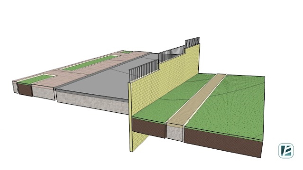
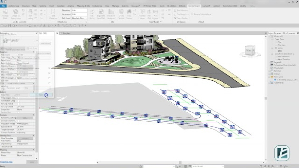
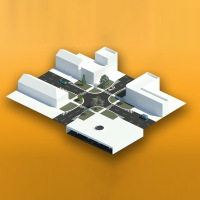
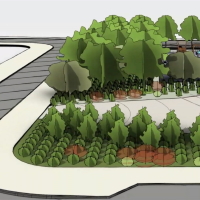
Designing topographies and hardscapes.
See the easiest and most intuitive way of designing sloped surfaces using contour lines.
To maximize design flexibility when modeling terrain, you can use both simple topographies and slabs to represent hardscapes.
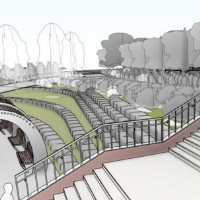
Use of architectural wall in site design.
Learn how to save time designing and modeling retaining walls in sloped areas or road construction.
Since calculating and drawing these walls with all necessary documentation can take up a lot of time, we have automated the design process of the walls as well as the drawing production of wall elevations.
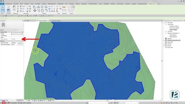
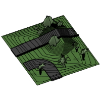
Topography analysis in Revit®.
Start every project with an easy study of the existing terrain.
Thanks to our color analysis feature, you can instantly present and analyze slopes and heights or obtain average data for existing topographies. This fast option allows better design decisions at the earliest stage of the project.
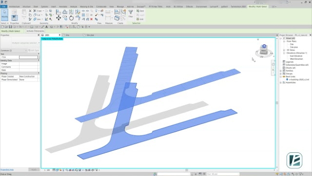
CAD file collaboration in site design.
Easily extract CAD data to your project without leaving Revit®.
Despite the rapid implementation of BIM technologies, AutoCAD still remains an integral part of the design workflow. The CAD files you insert to Revit® contains project information that must be considered when designing the project.
To simplify the process of transferring CAD data to your Revit® model, we created some fantastic shortcuts.
Learning & implementation
Since one of the biggest obstacles in making the transition to BIM is the lack of clear guidance and learning resources that fits our field, we also provide quality free online learning resources to make BIM implementation for all landscape professionals not only achievable, but fun.
Autodesk®, AutoCAD®, and Revit® are registered trademarks or trademarks of Autodesk, Inc., in the United States, Israel, and other countries.